


Reef map grows
 Print
Print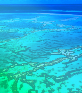 Satellites show there is more coral reef area across the globe than previously thought.
New University of Queensland-led research has identified 348,000 square kilometres of shallow coral reefs, up to 20-30 metres deep.
“This revises up our previous estimate of shallow reefs in the world’s oceans,” says researcher Dr Mitchell Lyons from UQ’s School of the Environment.
“Importantly, the high-resolution, up-to-date mapping satellite technology also allows us to see what these habitats are made from.
“We’ve found 80,000 square kilometres of reef have a hard bottom, where coral tends to grow, as opposed to soft bottom like sand, rubble or seagrass.
“This data will allow scientists, conservationists, and policymakers to better understand and manage reef systems.”
More than 1.5 million samples and 100 trillion pixels from the Sentinel-2 and Planet Dove CubeSat satellites were used to capture fine scale detail on a high-resolution global map.
“This is the first accurate depiction of the distribution and composition of the world’s coral reefs, with clear and consistent terminology,” Dr Lyons said.
“It’s more than just a map – it’s a tool for positive change for reefs and coastal and marine environments at large.”
UQ’s Associate Professor Chris Roelfsema said the reef mapping project, a collaboration with more than 480 contributors, is already being used in coral reef conservation around the world.
“The maps and associated data are publicly accessible through the Allen Coral Atlas and Google Earth Engine, reaching a global audience,” Dr Roelfsema said.
“They’re being used to inform projects in Australia, Indonesia, the Timor and Arafura Seas, Fiji, Solomon Islands, Tonga, Vanuatu, Panama, Belize, Bangladesh, India, Maldives, Sri Lanka, Kenya and western Micronesia.
“The details provided by these maps empowers scientists, policymakers and local communities to make informed decisions for the preservation of our coral reefs.”