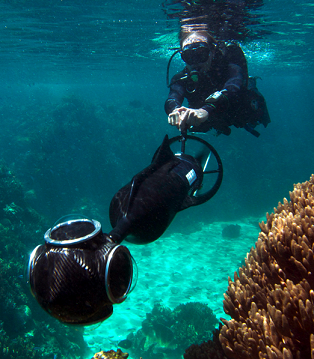
Undersea photoshoot expanded for science
 A massive 3-D survey of the Great Barrier Reef last year continues to have benefits for the endangered natural wonder, and will now be expanded to other reefs.
The Catlin Seaview Survey made the Reef accessible to anyone on the internet, and was then integrated to make a ‘street view’ of the Reef in Google Maps.
The Catlin Survey is now going a step further, launching the Catlin Global Reef Record; a free online resource that will make the survey's invaluable imagery open to scientific researchers.
“The Catlin Global Reef Record is a game-changing analytic tool that scientists and reef managers around the world now have at their fingertips,” said UQ's Professor Ove Hoegh-Guldberg, who is also chief scientist of the Catlin Seaview Survey.
Virtual visitors to the electronic library will be able to pore over around 180,000 panoramic underwater coral reef images with another 200,000 undersea vistas expected by the end of next year.
The University of Queensland's Professor Ove Hoegh-Guldberg, who is also chief scientist of the Catlin Seaview Survey, says: “Through the Record we will be able to monitor change in marine environments now and in the future... it will be available to high schools, universities and scientists working on coral research.”
Estimates say around 50 per cent of coral reefs worldwide have been lost in the past 50 years, with 75 per cent of coral reefs today threatened by stressors such as overfishing, pollution, unsustainable coastal development and ocean acidification.
Professor Hoegh-Guldberg, who is also the Director of UQ's Global Change Institute (GCI), says many countries are ill-equipped to maintain their coral reef ecosystems.
“There is often limited baseline data available for identifying the drivers of change on coral reefs,” he said, “without this information, understanding change and implementing coastal management strategies for arresting the downward trend in the condition of coral reefs can be extremely difficult.”
The undersea survey is taken with special equipment to ensure the reefs are shown in their best and brightest light. Data is captured using a custom-designed underwater camera, which integrates three digital SLR cameras positioned at an angle that allows the Catlin Seaview Survey team to record 360-degree panoramas. The footage is then used to create 3D reconstructions of reef ecosystems, providing a visual technique to assess reef populations.
Both the Catlin Global Reef Record and the Catlin Seaview Survey are sponsored by Catlin Group Limited, an international, specialty property and casualty insurance firm.


 Print
Print